Open Ecology
Use cases, with real answers
Real questions, the tool that answered and what came back. Every answer here was captured from the live service and nothing is mocked up; the tools marked Pilot need the pilot endpoint.
Confirm the site
A client gives a street address, and before anything else the job needs the lot on plan, its area and the council.
- What lot is 688 Peachester Road, Peachester, and how big is it?
- Lot
- 2SP237589
- Matched address
- 688 Peachester Road, Peachester, Sunshine Coast Regional, QLD
- Area
- 15.99 ha (Recorded lot area (Queensland cadastre). Not a survey.)
- Council
- Sunshine Coast Regional
- Tenure
- Freehold
- MGA2020
- Zone 56, E 490119.87, N 7031219.47
Desktop constraints review with a neighbour buffer
Every mapped constraint on the lot, and what is mapped within 100 m of it, in one request.
- Run every constraint on 2SP237589 with a 100 m buffer.
- What is mapped within 100 m of 2SP237589?
- Run every constraint on 2SP237589. Which layers came from the copy?
- Site
- 2SP237589, 15.98 ha, Sunshine Coast Regional
- Read from
- 32 of 54 constraints were read from Open Ecology's copy of the government layers (built 2026-10-05 to 2026-10-06, last checked against the sources 2026-10-06); the rest were asked of the source now. Each constraint's source block says which.
Mapped (20 State layers, 9 council layers; first 6 shown):
- Regulated vegetation management map: Category B: 12.55 ha (78.5% of the lot); Category X: 2.13 ha (13.3% of the lot); Category C: 1.30 ha (8.1% of the lot)
Within 100 m of the lot (off it): Category B (18.17 ha, nearest 0 m); Category X (3.29 ha, nearest 0 m); Category C (1.82 ha, nearest 0 m). - Regional ecosystems: 12.9-10.14 (least concern): 13.85 ha (86.7% of the lot); Non-remnant: 2.13 ha (13.3% of the lot)
Within 100 m of the lot (off it): 12.9-10.14 (least concern) (19.84 ha, nearest 0 m); Non-remnant (3.29 ha, nearest 0 m); 12.9-10.16 (of concern) (0.15 ha, nearest 61 m); 12.3.2/12.9-10.14 (of concern and least concern) (<0.01 ha, nearest 94 m). - High value regrowth: High value regrowth: 1.30 ha (8.1% of the lot)
Within 100 m of the lot (off it): High value regrowth (1.73 ha, nearest 0 m). - Essential habitat: Essential habitat (category A or B): 12.55 ha (78.5% of the lot); Essential habitat (category C): 1.30 ha (8.1% of the lot)
Within 100 m of the lot (off it): Essential habitat (category A or B) (17.85 ha, nearest 0 m); Essential habitat (category C) (1.72 ha, nearest 0 m). - Vegetation management wetlands and watercourses: Watercourse: 308 m; Watercourse (stream order 1): 165 m
Within 100 m of the lot (off it): Watercourse (8, nearest 0 m); Watercourse (stream order 1) (5, nearest 0 m). - Protected plants flora survey trigger map: High risk area: 11.91 ha (74.5% of the lot)
Within 100 m of the lot (off it): High risk area (14.07 ha, nearest 0 m).
Checked and not mapped: 25 layers.
A paste-ready desktop appendix
The same check written up as a report appendix, grouped by Act, with method, limitations and sources.
- What is mapped on 688 Peachester Road, Peachester? Give me the desktop appendix.
- Give me the desktop constraints appendix for 2SP237589.
The appendix came back as 12863 characters of Markdown, ready to paste; the first part, exactly as returned:
## Desktop constraints assessment - Lot 2 on SP237589, 688 Peachester Road Peachester QLD, Sunshine Coast Regional Council

Mapped government datasets for Queensland and Sunshine Coast Regional Council were queried live on 5 October 2026 through Open Ecology (openecology.com.au). Each layer was measured against the cadastral boundary of Lot 2 on SP237589 (15.98 ha) in GDA2020 Australian Albers. Slivers below 0.01% of the lot are treated as boundary misalignment and left out. Constraint areas overlap, so the percentages do not add up to 100%. The mapping has not been verified in the field.

### Vegetation Management Act 1999 (Qld)

High value regrowth here is the Queensland Herbarium layer, which is separate from category C on the regulated vegetation management map.

| Constraint | Mapped on the lot | Data version | Source service |
|---|---|---|---|
| Regulated vegetation management map (categories A, B, C, R, X) | Category B (12.55 ha, 78.5% of the lot); Category X (2.13 ha, 13.3% of the lot); Category C (1.30 ha, 8.1% of the lot) | 7.28 | VegetationManagement |
| Regional ecosystems (vegetation management regional ecosystem map) | 12.9-10.14 (least concern) (13.85 ha, 86.7% of the lot); Non-remnant (2.13 ha, 13.3% of the lot) | 13 | VegetationManagement |
| High value regrowth (Queensland Herbarium regional ecosystem mapping) | High value regrowth (1.30 ha, 8.1% of the lot) | - | RegionalEcosystemMapping |
| Essential habitat | Essential habitat (category A or B) (12.55 ha, 78.5% of the lot); Essential habitat (category C) (1.30 ha, 8.1% of the lot) | 12.28 | VegetationManagement |
| Vegetation management wetlands and watercourses | Watercourse (308 m); Watercourse (stream order 1) (165 m) | - | VegetationManagement |

...
A report figure
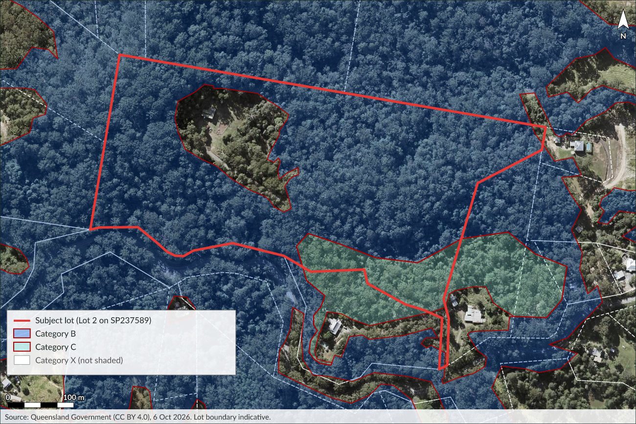
Regulated vegetation on the lot, drawn on the State's aerial, with a caption and the areas the report quotes.
- Draw a report figure of regulated vegetation on 2SP237589.
- Caption
- Figure N. Regulated vegetation management map at Lot 2 on SP237589, Peachester (current aerial imagery). Source: Queensland cadastre, Regulated vegetation management map version 7.28 (retrieved 6 October 2026) and Queensland Imagery, Queensland Government, CC BY 4.0. Indicative only; not a survey.
- Regulated vegetation management map
- 13.84 ha on the lot (86.66%)
drafting_render.Land-use history
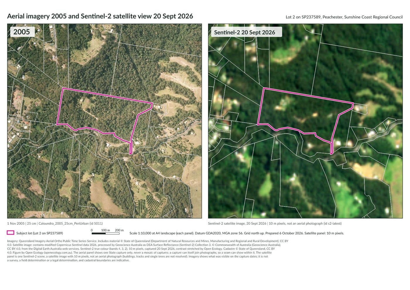
Which aerial photographs exist for the lot, then the 2005 capture beside the latest view.
- What historical aerial photos are there for 2SP237589?
- Compare 2SP237589 in 2005 and now.
- Show the latest satellite view of 2SP237589.
The State holds 17 captures over the lot, the first from 1994; the newest five are listed here:
- 2026: 20 Sept 2026, 10 m, latest satellite view (id s2-latest)
- 2022: 24 July 2022 to 12 Sept 2022, 10 cm (id 5636)
- 2021: 27 July 2021 to 17 Aug 2021, 10 cm (id 5314)
- 2020: 2 May 2020 to 25 May 2020, 10 cm (id 5196)
- 2019: 28 May 2019 to 17 June 2019, 10 cm (id 4887)
- Panels
- 2005 and 2026
- Alt text
- Two images of Lot 2 on SP237589 at Peachester side by side, 2005 on the left and the Sentinel-2 satellite image (10 m pixels) of 20 Sept 2026 on the right, with the lot outlined in magenta.
imagery_compare.Files for the field
The lot and its mapped constraints as KML, GeoJSON and GPX for Avenza Maps, QGIS or a handheld GPS.
- Give me KML and GPX of 2SP237589 and its constraints for the field.
Links returned: KML, GEOJSON, GPX, covering 12 layers. Each link re-reads the live data when opened, so the links are not reproduced here.
Council scheme and development applications
Which planning scheme applies, and whether the council's open data shows applications on the lot.
- Any development applications on 2SP237589?
- Which planning scheme applies at Peachester, and what has changed this year?
- Council
- Sunshine Coast Regional Council
- Scheme in force
- The planning scheme in force today for Sunshine Coast Regional Council is not held: Queensland schemes and amendments are published as Gazette notices, a source awaiting a licence decision. The council's website has the scheme in force and its amendments.
- Council's scheme page
- https://www.sunshinecoast.qld.gov.au/development/planning-documents/sunshine-coast-planning-scheme-2014
- Status
- none_found
- Coverage
- Development applications lodged with Sunshine Coast Council (Development.i holds them from 1 January 2007, with some earlier records); building and plumbing applications are separate layers and not included. Applications under the Economic Development Act 2012 in the Caloundra South and Maroochydore City Centre priority development areas are not included.
- Note
- No application in this source is mapped to this lot. That is not evidence that there are no applications; Sunshine Coast Regional Council's own register is the record.
A Victorian site
The same questions for a Victorian address: the lot, then the zones and overlays mapped on it.
- What lot is 1 Spring Street, Melbourne?
- What constraints apply to 1 Spring Street, Melbourne?
- Lot
- 1\TP800196
- Matched address
- 1 SPRING STREET MELBOURNE 3000
- Area
- 0.5245 ha (Calculated by Open Ecology from the Vicmap parcel boundary in GDA2020 Australian Albers (equal-area). Not a recorded title area and not a survey.)
- Council
- Melbourne
- MGA2020
- Zone 55, E 321710.77, N 5812770.38
- Site
- 1\TP800196, 0.52 ha, Melbourne
- Read from
- 1 of 14 constraints were read from Open Ecology's copy of the government layers (built 2026-10-06, last checked against the sources 2026-10-06); the rest were asked of the source now. Each constraint's source block says which.
Mapped (5 State layers; first 5 shown):
- Planning scheme zones: CCZ1 Capital City Zone - Schedule 1: 0.52 ha (100% of the lot)
- Planning scheme overlays: DDO1 Design And Development Overlay - Schedule 1: 0.52 ha (100% of the lot); DDO10 Design And Development Overlay - Schedule 10: 0.52 ha (100% of the lot); PO1 Parking Overlay - Precinct 1: 0.52 ha (100% of the lot); SCO8 Specific Controls Overlay - PS Map Ref SCO8: 0.52 ha (100% of the lot); HO1235 Heritage Overlay (HO1235): 0.47 ha (90.5% of the lot); HO637 Heritage Overlay (HO637): 0.05 ha (9.5% of the lot)
- Pre-1750 ecological vegetation classes: Plains Grassy Woodland (EVC 55), endangered: 0.52 ha (100% of the lot)
- Victorian Heritage Register places: 1 Spring Street (Shell House) (VHR H2365): 0.47 ha (90.5% of the lot); Milton House (VHR H0582): 0.05 ha (9.5% of the lot). Within 100 m of the lot (off it): Former Campbell Residence (VHR H1945): 1 (nearest 87 m); The Herald & Weekly Times Building (VHR H1147): 1 (nearest 52 m); Treasury Gardens (VHR H1887): 1 (nearest 29 m).
- Victorian Heritage Inventory sites: Milton House (H7822-1951): 0.05 ha (9.2% of the lot). Within 100 m of the lot (off it): 1-9 Collins Street (H7822-1832): 1 (nearest 68 m); 11 Collins Street (H7822-1833): 1 (nearest 67 m); 31-35 Flinders Lane (H7822-1952): 1 (nearest 11 m); 37- 45 Flinders Lane (H7822-1953): 1 (nearest 24 m); 61-73 Flinders Lane (H7822-1955): 1 (nearest 69 m).
Checked and not mapped: 9 layers.
Threatened species near the site
Which listed species have been recorded within a kilometre of the lot, with their status under State law and the EPBC Act, then the card for one of them.
- What is the status of the koala in Queensland and under the EPBC Act?
- Which threatened species are recorded within 1 km of 2SP237589?
- Searched
- within 1 km of the lot: a circle centred on the lot, of radius 0.5 km (the lot's half-diagonal) plus 1 km, so the distance is measured from about the lot boundary (more than 1 km off the lot's shorter sides)
- Found
- 180 species from 2472 records, 9 of them listed or significant
- Source
- Queensland Government WildNet database, Qld WildNet Data API (CC BY 4.0)
| Species | State status | EPBC Act | Records | Last record |
|---|---|---|---|---|
| Phascolarctos cinereus (koala) | Endangered | Endangered | 2 | 2006 |
| Adelotus brevis (tusked frog) | Vulnerable | 9 | not given | |
| Hirundapus caudacutus (white-throated needletail) | Vulnerable | Vulnerable | 4 | 1994 |
| Ninox strenua (powerful owl) | Vulnerable | 2 | 2000 | |
| Apus pacificus (fork-tailed swift) | Special least concern | 2 | 1994 | |
| Plegadis falcinellus (glossy ibis) | Special least concern | 1 | 1992 | |
| Ornithorhynchus anatinus (platypus) | Special least concern | 1 | 1993 | |
| Tachyglossus aculeatus (short-beaked echidna) | Special least concern | 1 | 1993 | |
| Pterostylis erecta | Special least concern | 2 | 2018 |
Records show where a species has been reported to the database. The absence of records is not evidence that a species is absent: most land has never been surveyed.
- Species
- Phascolarctos cinereus (koala)
- State status
- Endangered, from 2022-04-08 (Nature Conservation (Animals) Regulation 2020, Schedule 1)
- EPBC Act
- Endangered, from 2022-02-12 (Environment Protection and Biodiversity Conservation Act 1999 (Cth))
- Notes
- Commonwealth conservation advice in effect from 2022-02-12 (SPRAT). Commonwealth recovery plan dated 2022-04-08 (SPRAT). EPBC listing is for "Phascolarctos cinereus (combined populations of Qld, NSW and the ACT)".
- Links
- WildNet species profile (Queensland); Species Profile and Threats Database (Commonwealth); Survey guidelines for Australia's threatened mammals (Commonwealth)
A New South Wales site
NSW has no open lot boundaries, so the address resolves to its G-NAF point and constraints are measured in a 100 m circle around it, and the answer says so.
- Look up 1 Macquarie Street, Sydney.
- Check constraints within 100 m of 1 Macquarie Street, Sydney.
- Lot
- CP//SP58841
- Matched address
- 1 MACQUARIE STREET, SYDNEY NSW 2000
- Council
- Sydney
- MGA2020
- Zone 56, E 334711.2, N 6252005.14
- Notes
- Constraint checks for this site use a circle (radius_m, default 100 m) around the address point, not a lot boundary: NSW lot boundaries are not available yet.
- Site
- 100 m radius around the G-NAF address point for 1 MACQUARIE STREET, SYDNEY NSW 2000 (not the lot boundary)
Mapped (6 State layers; first 6 shown):
- Native Vegetation Regulatory Map - category information: Excluding land zoning and tenures: 3.14 ha (100% of the search area)
- Coastal environment and coastal use areas: Coastal Environment Area: 3.14 ha (100% of the search area); Coastal Use Area: 2.21 ha (70.5% of the search area)
- Land zoning: SP5 Metropolitan Centre (Sydney Local Environmental Plan 2012): 1.34 ha (42.6% of the search area); RE1 Public Recreation (Sydney Local Environmental Plan 2012): 0.88 ha (27.9% of the search area)
- Heritage items and conservation areas: Item - General: Royal Botanic Gardens (state significance): 0.64 ha (20.4% of the search area); Item - General: Sydney Opera House (state significance): 0.28 ha (9% of the search area); Item - General: Steps & rock face 'Tarpeian Rock' (local significance): 0.11 ha (3.4% of the search area); Item - General: Cast iron railings (local significance): 0.08 ha (2.7% of the search area); Item - General: Palm trees (local significance): 0.05 ha (1.5% of the search area); Item - General: Government House & garden group (local significance): 0.03 ha (0.93% of the search area); Item - General: Commercial building group 'Sydney Cove Oyster Bar' & 'Portobella Cafe' (local significance): 0.01 ha (0.4% of the search area)
- State Heritage Register items: Royal Botanic Gardens and Domain (SHR 01070, listed 1999-04-02): 0.75 ha (24.1% of the search area); Sydney Opera House (SHR 01685, listed 2003-12-03): 0.29 ha (9.2% of the search area); Government House, Movable Heritage Collection and Gardens (SHR 01872, listed 2011-12-13): 0.02 ha (0.74% of the search area); Railings, Sydney Cove (SHR 01572, listed 2002-05-10): 0.01 ha (0.44% of the search area)
- Commonwealth heritage: National and Commonwealth Heritage Lists and World Heritage: National Heritage List: Sydney Cultural Crescent Rock Art (place 106369, nominated place, indigenous): 3.14 ha (100% of the search area); World Heritage: Sydney Opera House - Buffer Zone (buffer zone, inscribed 2007): 2.85 ha (90.8% of the search area); National Heritage List: Governors' Domain and Civic Precinct (place 106103, listed place, historic, listed 2021-02-12): 1.14 ha (36.5% of the search area); World Heritage: Sydney Opera House (declared property, inscribed 2007): 0.29 ha (9.2% of the search area); National Heritage List: Sydney Opera House (place 105738, listed place, historic, listed 2005-07-12): 0.29 ha (9.2% of the search area)
Checked and not mapped: 8 layers.